
Southwest Sumba earthquake: casualty reports differ as damage assessments continue
Earthquake
How the score is calculated
The score starts at 8. It adds points from recorded affected, deaths, displaced and casualty counts, plus terms found in the story title, event type or status. For each count, only its highest matching band is used.
- Affected people
- 1–999: +5 · 1,000–9,999: +12 · 10,000–99,999: +20 · 100,000–999,999: +28 · 1 million+: +35
- Deaths
- 1–9: +8 · 10–99: +14 · 100–999: +22 · 1,000+: +30
- Displaced people
- 1–9,999: +6 · 10,000–99,999: +12 · 100,000+: +18
- Casualties
- 100 or more: +8
- Story wording
- +10 for terms such as catastrophe, famine, war, conflict, major earthquake, mass casualty or critical. Otherwise, +5 for active, ongoing, emergency, outbreak, cyclone or hurricane.
Score bands: Watch 0–24 · Moderate 25–49 · High 50–74 · Critical 75–100. Scores are capped at 100. Missing or unparseable figures add no points.
This is a rule-based WorldsAid triage indicator, not an official or independently validated classification. It does not account for recency or local context, and it can understate events with incomplete reporting. Check the linked sources.
In brief
- What happenedA shallow offshore earthquake struck southwest of Kodi in Southwest Sumba, East Nusa Tenggara, on 4 October 2026.
- Reported impactInitial BMKG event card: M6.1 · 10 km depth · about 14 km southwest of Kodi · 05:55:52 WIB · BNPB initial report via ANTARA: Epicentre at sea about 14 km southwest of Kodi · 10 km depth · strong shaking about one minute in Southwest Sumba, West Sumba and West Manggarai · BMKG revised main-event parameters: M5.9 · 30 km depth · about 59 km southwest of Kodi · revised analysis; not averaged with the initial card
- What help is neededResponse priorities should be confirmed in the linked source reports as needs change.
What changed
Updated verified snapshot
This record was first dated 2026-10-04 and last verified 2026-10-05.
Situation
A shallow offshore earthquake struck southwest of Kodi in Southwest Sumba, East Nusa Tenggara, on 4 October 2026. BMKG’s initial event card listed magnitude 6.1, 10 km depth and a location 14 km southwest of Kodi; BMKG later updated its analysis to magnitude 5.9, 30 km depth and 59 km southwest of Kodi, and said its tsunami model showed no tsunami threat. ANTARA, quoting BNPB, said strong shaking lasted about one minute across Southwest Sumba, West Sumba and West Manggarai, with residents running outdoors. GDACS independently lists magnitude 5.9 at 46 km depth and estimates 130,000 people exposed to modelled MMI V shaking. That is modelled exposure, not a confirmed count of people affected.
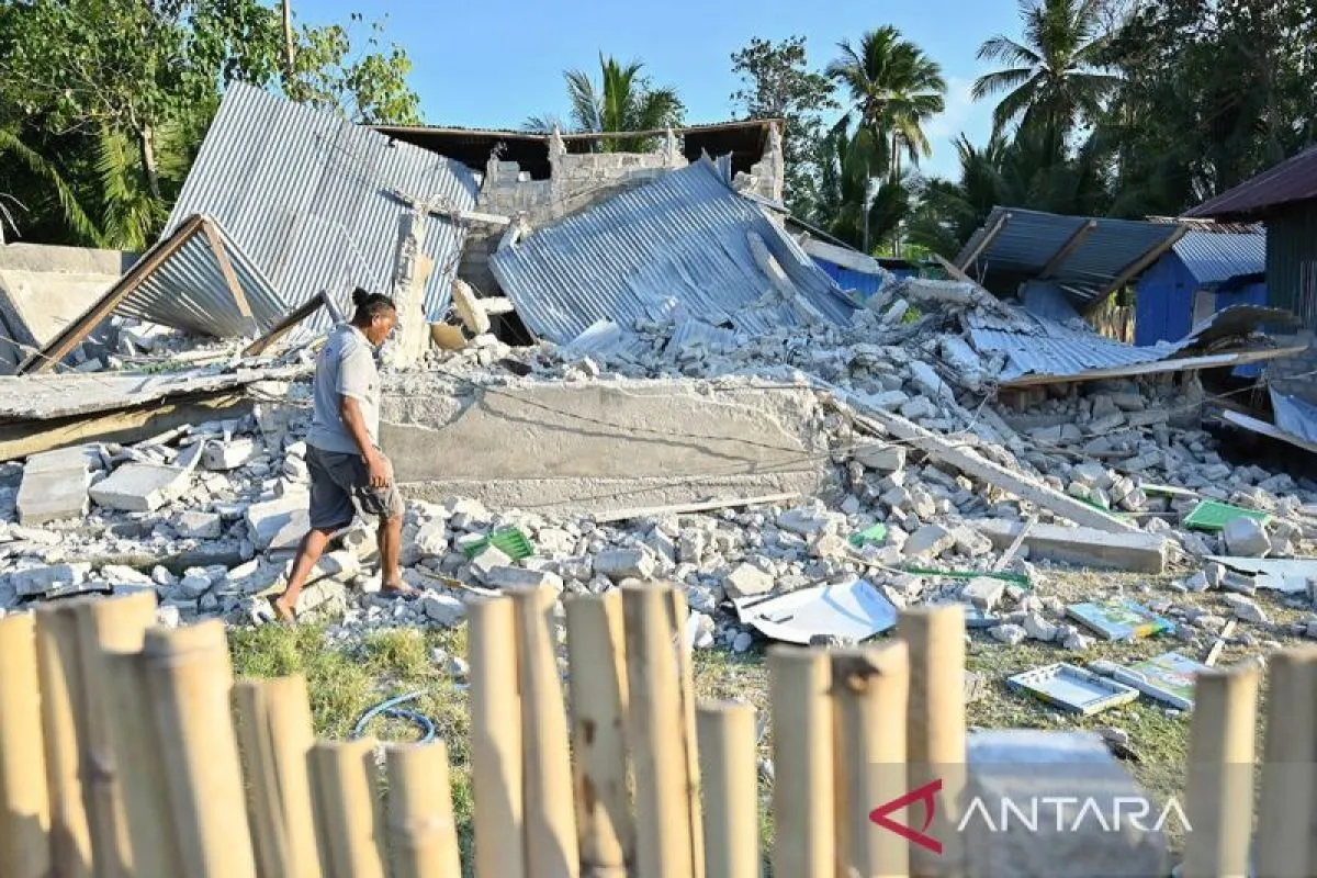
BMKG reported VI MMI shaking in Kodi Balaghar, Kodi Bangedo and Kodi, and 62 aftershocks of magnitude 1.5–4.3 through 08:05 WIB. A BMKG press release said one person had a light injury and some buildings had moderate damage by 08:40 WIB. Later, ANTARA citing BNPB reported 20 affected homes in Southwest Sumba (19 lightly damaged and one moderately damaged), three lightly damaged places of worship, one school and one village family-planning hall; it separately described light damage to three Koramil houses or dormitories and two KDKMP buildings in West Sumba.
Casualty accounts remain source-distinct: ANTARA citing North Kodi police reported that a 73-year-old resident died after being startled by the shaking, while a later ANTARA report citing BNPB said there were no deaths and one light injury in its assessment. These reports are not reconciled here. No displacement total or confirmed affected-population total is available in the cited sources.
WorldsAid verification
A WorldsAid editor reviewed this record against 6 attributed sources, cleaned feed formatting and checked the crisis, place and reporting date. 10 human-impact figures were separated from the narrative and dated where the source allowed. Earlier observations remain in the evidence history instead of being silently overwritten.
Verified figures
- Initial BMKG event card
- M6.1 · 10 km depth · about 14 km southwest of Kodi · 05:55:52 WIB retained at 2026-10-05
- BNPB initial report via ANTARA
- Epicentre at sea about 14 km southwest of Kodi · 10 km depth · strong shaking about one minute in Southwest Sumba, West Sumba and West Manggarai retained at 2026-10-05
- BMKG revised main-event parameters
- M5.9 · 30 km depth · about 59 km southwest of Kodi · revised analysis; not averaged with the initial card retained at 2026-10-05
- GDACS parameters and exposure
- M5.9 · 46 km depth · 130,000 modelled exposure at MMI V; not confirmed affected population retained at 2026-10-05
- Felt intensity
- VI MMI reported for Kodi Balaghar, Kodi Bangedo and Kodi; BMKG press release, 4 October retained at 2026-10-05
- Aftershocks
- 62 events of M1.5–M4.3 through 08:05 WIB · BMKG retained at 2026-10-05
- Southwest Sumba damage
- BNPB via ANTARA: 20 homes (19 light, 1 moderate), 3 places of worship, 1 school and 1 family-planning hall reported affected retained at 2026-10-05
- West Sumba damage
- BNPB via ANTARA separately reports 3 lightly damaged Koramil houses/dormitories and 2 KDKMP buildings retained at 2026-10-05
- Casualty reports
- BNPB via ANTARA: 1 light injury, no deaths reported; separate ANTARA report citing local police: 1 older resident died after being startled. Source accounts differ; not reconciled. retained at 2026-10-05
- Displacement and affected population
- No confirmed total reported in cited sources; GDACS exposure is modelled and is not an affected-population count retained at 2026-10-05
What we knew when
- WorldsAid record entered the retained historical dataset.
- INITIAL BMKG EVENT CARD · M6.1 · 10 KM · 14 KM SOUTHWEST OF KODI preserved as a dated, source-linked observation. Source
- BMKG PRESS RELEASE · REVISED M5.9 / 30 KM / 59 KM SOUTHWEST OF KODI · 62 AFTERSHOCKS · 1 LIGHT INJURY preserved as a dated, source-linked observation. Source
- LOCAL-POLICE ACCOUNT VIA ANTARA · 1 FATALITY REPORTED preserved as a dated, source-linked observation. Source
- BNPB DAMAGE UPDATE VIA ANTARA · 20 SOUTHWEST SUMBA HOMES AND OTHER FACILITIES · 1 LIGHT INJURY · NO DEATHS IN THIS ACCOUNT preserved as a dated, source-linked observation. Source
- GDACS · M5.9 AT 46 KM · 130,000 MODELLED EXPOSURE AT MMI V preserved as a dated, source-linked observation. Source
- ANTARA ENGLISH REPORT · NORTH KODI POLICE REPORTS 1 FATALITY; BNPB REPORTS INITIAL EPICENTRE, DEPTH AND ABOUT 1-MINUTE SHAKING preserved as a dated, source-linked observation. Source
Earlier figures are never replaced by later values; additional observations are retained as new ledger entries.
Provenance
This page renders the last verified WorldsAid cache directly in HTML. It does not treat generated summaries as primary evidence.
Cached dataset: worldsai_drup771.sql.gz
Verified
SHA-256 bc647dffd8df34250a9fcbb1a053614af61e36de4f4df4573a5625158b74439b- BMKG · initial event parameters and later M5.9 parameter update · 4 October 2026
- BMKG press release · revised parameters, felt intensity, aftershocks, one light injury and damage assessment · 4 October 2026
- GDACS · M5.9, 46 km depth and modelled exposure estimate · not a confirmed affected-population count
- ANTARA · citing North Kodi police on a separately reported fatality · 4 October 2026
- ANTARA · citing BNPB on scoped building damage, one light injury and no deaths in its report · 4 October 2026
- ANTARA English · police report one fatality; BNPB initial parameters and shaking duration · 4 October 2026